|
| at: |
Francis Marion National Forest |
Data from USFS GIS
 show on map
 animate
Trail users:


Elevation Profile
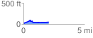
 2.075030 mi
 110.18 ft
 100.72 ft
 9.46 ft
 1.01 %
GPX Downloads: Track Route
![]()
|
| at: |
Francis Marion National Forest |
show on map
animate
2.075030 mi
110.18 ft
100.72 ft
9.46 ft
1.01 %