|
| at: |
Francis Marion National Forest |
Data from USFS GIS
 show on map
 animate
Trail users:


Elevation Profile
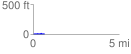
 0.691705 mi
 16.90 ft
 14.25 ft
 2.64 ft
 0.46 %
GPX Downloads: Track Route
![]()
|
| at: |
Francis Marion National Forest |
show on map
animate
0.691705 mi
16.90 ft
14.25 ft
2.64 ft
0.46 %