|
| at: |
Francis Marion National Forest |
Data from USFS GIS
 show on map
 animate
Trail users:


Elevation Profile
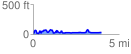
 3.993822 mi
 498.66 ft
 480.69 ft
 17.97 ft
 2.36 %
GPX Downloads: Track Route
![]()
|
| at: |
Francis Marion National Forest |
show on map
animate
3.993822 mi
498.66 ft
480.69 ft
17.97 ft
2.36 %