|
| at: |
Francis Marion National Forest |
Data from USFS GIS
 show on map
 animate
Trail users:


Elevation Profile
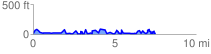
 7.811991 mi
 1471.29 ft
 1426.07 ft
 45.22 ft
 3.57 %
GPX Downloads: Track Route
![]()
|
| at: |
Francis Marion National Forest |
show on map
animate
7.811991 mi
1471.29 ft
1426.07 ft
45.22 ft
3.57 %