|
| at: |
Francis Marion National Forest |
Data from USFS GIS
 show on map
 animate
Trail users:


Elevation Profile
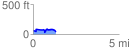
 1.301111 mi
 135.83 ft
 154.17 ft
 -18.34 ft
 2.24 %
GPX Downloads: Track Route
![]()
|
| at: |
Francis Marion National Forest |
show on map
animate
1.301111 mi
135.83 ft
154.17 ft
-18.34 ft
2.24 %