|
| at: |
Francis Marion National Forest |
Data from USFS GIS
 show on map
 animate
Trail users:


Elevation Profile
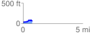
 0.772514 mi
 101.75 ft
 84.18 ft
 17.57 ft
 2.49 %
GPX Downloads: Track Route
![]()
|
| at: |
Francis Marion National Forest |
show on map
animate
0.772514 mi
101.75 ft
84.18 ft
17.57 ft
2.49 %