|
| at: |
Sumter National Forest - Andrew Pickens District |
Data from USFS GIS
 show on map
 animate
Trail users:


Elevation Profile
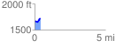
 0.415185 mi
 90.27 ft
 50.89 ft
 39.38 ft
 4.12 %
GPX Downloads: Track Route
![]()
|
| at: |
Sumter National Forest - Andrew Pickens District |
show on map
animate
0.415185 mi
90.27 ft
50.89 ft
39.38 ft
4.12 %