| at: |
Fort Mountain State Park Area |
Data from David Muse
 show on map
 animate
Trail users:


Elevation Profile
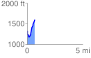
 0.694577 mi
 425.77 ft
 152.89 ft
 272.88 ft
 11.61 %
GPX Downloads: Track Route
![]()
| at: |
Fort Mountain State Park Area |
show on map
animate
0.694577 mi
425.77 ft
152.89 ft
272.88 ft
11.61 %