|
| at: |
Sumter National Forest - Andrew Pickens District Rocky Gap Horse Trail |
Data from USFS GIS
 show on map
 animate
Trail users:


Elevation Profile
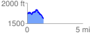
 1.490728 mi
 302.78 ft
 421.44 ft
 -118.66 ft
 5.35 %
GPX Downloads: Track Route