|
| at: |
Sumter National Forest - Andrew Pickens District |
Data from USFS GIS
 show on map
 animate
Trail users:


Elevation Profile
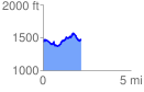
 2.173602 mi
 516.35 ft
 456.72 ft
 59.63 ft
 4.50 %
GPX Downloads: Track Route
![]()
|
| at: |
Sumter National Forest - Andrew Pickens District |
show on map
animate
2.173602 mi
516.35 ft
456.72 ft
59.63 ft
4.50 %