|
| at: |
Sumter National Forest - Andrew Pickens District |
Data from USFS GIS
 show on map
 animate
Trail users:


Elevation Profile
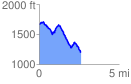
 2.662319 mi
 363.10 ft
 847.90 ft
 -484.80 ft
 6.03 %
GPX Downloads: Track Route
![]()
|
| at: |
Sumter National Forest - Andrew Pickens District |
show on map
animate
2.662319 mi
363.10 ft
847.90 ft
-484.80 ft
6.03 %