|
| at: |
Sumter National Forest - Andrew Pickens District |
Data from USFS GIS
 show on map
 animate
Trail users:


Elevation Profile
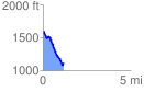
 1.150046 mi
 105.38 ft
 542.40 ft
 -437.02 ft
 8.93 %
GPX Downloads: Track Route
![]()
|
| at: |
Sumter National Forest - Andrew Pickens District |
show on map
animate
1.150046 mi
105.38 ft
542.40 ft
-437.02 ft
8.93 %