|
| at: |
Sumter National Forest - Andrew Pickens District Rocky Gap Horse Trail |
Data from USFS GIS
 show on map
 animate
Trail users:


Elevation Profile
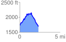
 2.341888 mi
 630.73 ft
 715.40 ft
 -84.67 ft
 5.79 %
GPX Downloads: Track Route