|
| at: |
Sumter National Forest - Andrew Pickens District Rocky Gap Horse Trail |
Data from USFS GIS
 show on map
 animate
Trail users:


Elevation Profile
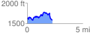
 2.267553 mi
 557.90 ft
 590.75 ft
 -32.85 ft
 4.93 %
GPX Downloads: Track Route