| at: |
Sumter National Forest - Andrew Pickens District Burrells Ford |
Data from USFS GIS
 show on map
 animate
Trail users:

Elevation Profile
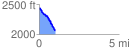
 1.001505 mi
 54.95 ft
 440.62 ft
 -385.66 ft
 8.33 %
GPX Downloads: Track Route
![]()
| at: |
Sumter National Forest - Andrew Pickens District Burrells Ford |
show on map
animate
1.001505 mi
54.95 ft
440.62 ft
-385.66 ft
8.33 %