| at: |
Sumter National Forest - Andrew Pickens District Yellow Branch Falls |
Data from USFS GIS
 show on map
 animate
Trail users:

Elevation Profile
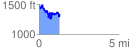
 1.323021 mi
 574.57 ft
 690.49 ft
 -115.92 ft
 9.88 %
GPX Downloads: Track Route
![]()
| at: |
Sumter National Forest - Andrew Pickens District Yellow Branch Falls |
show on map
animate
1.323021 mi
574.57 ft
690.49 ft
-115.92 ft
9.88 %