| at: |
Sumter National Forest - Andrew Pickens District Rocky Gap Horse Trail |
Data from USFS GIS
 show on map
 animate
Trail users:


Elevation Profile
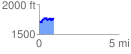
 0.939819 mi
 315.74 ft
 256.87 ft
 58.87 ft
 6.36 %
GPX Downloads: Track Route
![]()
| at: |
Sumter National Forest - Andrew Pickens District Rocky Gap Horse Trail |
show on map
animate
0.939819 mi
315.74 ft
256.87 ft
58.87 ft
6.36 %