| at: |
Sumter National Forest - Andrew Pickens District Oconee State Park Oconee Station |
Data from USFS GIS
 show on map
 animate
Trail users:


Elevation Profile
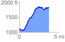
 3.761568 mi
 1398.17 ft
 732.83 ft
 665.34 ft
 7.04 %
GPX Downloads: Track Route
Trailheads:
 Oconee Station