| at: |
Sawnee Mountain |
Data from David Muse
 show on map
 animate
A long section of this trail - basically the entire eastern side of it - was once called the Laurel Trail.
Trail users:
Elevation Profile
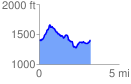
 3.243580 mi
 685.27 ft
 685.27 ft
 0.00 ft
 4.00 %
GPX Downloads: Track Route