| at: |
Tyler State Park |
Data from David Muse
 show on map
 animate
Trail users:


Elevation Profile
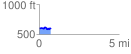
 0.738338 mi
 85.95 ft
 81.36 ft
 4.59 ft
 2.20 %
GPX Downloads: Track Route
Trailheads:
 Loop A/EZ
![]()
| at: |
Tyler State Park |
show on map
animate
0.738338 mi
85.95 ft
81.36 ft
4.59 ft
2.20 %
Loop A/EZ