| at: |
Tyler State Park |
Data from David Muse
 show on map
 animate
Trail users:


Elevation Profile
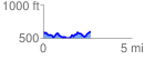
 2.674010 mi
 346.47 ft
 351.07 ft
 -4.59 ft
 2.49 %
GPX Downloads: Track Route
Trailheads:
 Loop A/EZ
![]()
| at: |
Tyler State Park |
show on map
animate
2.674010 mi
346.47 ft
351.07 ft
-4.59 ft
2.49 %
Loop A/EZ