| at: |
Tyler State Park |
Data from David Muse
 show on map
 animate
Trail users:


Elevation Profile
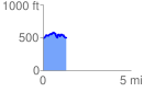
 1.340211 mi
 215.55 ft
 205.71 ft
 9.84 ft
 3.05 %
GPX Downloads: Track Route
Trailheads:
 Boat Ramp Lot
![]()
| at: |
Tyler State Park |
show on map
animate
1.340211 mi
215.55 ft
205.71 ft
9.84 ft
3.05 %
Boat Ramp Lot