| at: |
Bonnet Carre Spillway |
Data from David Muse
 show on map
 animate
Trail users:


Elevation Profile
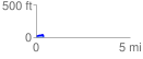
 0.425132 mi
 22.96 ft
 32.15 ft
 -9.19 ft
 1.43 %
GPX Downloads: Track Route
![]()
| at: |
Bonnet Carre Spillway |
show on map
animate
0.425132 mi
22.96 ft
32.15 ft
-9.19 ft
1.43 %