| at: |
Levee Bike Path (Baton Rouge Area) |
Data from David Muse
 show on map
 animate
Trail users:


Elevation Profile
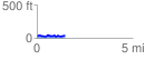
 1.457983 mi
 103.68 ft
 89.90 ft
 13.78 ft
 1.35 %
GPX Downloads: Track Route
![]()
| at: |
Levee Bike Path (Baton Rouge Area) |
show on map
animate
1.457983 mi
103.68 ft
89.90 ft
13.78 ft
1.35 %