| at: |
Levee Bike Path (St. Gabriel Area) |
Data from David Muse
 show on map
 animate
Trail users:


Elevation Profile
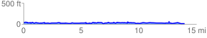
 14.169869 mi
 982.30 ft
 971.80 ft
 10.50 ft
 1.31 %
GPX Downloads: Track Route
![]()
| at: |
Levee Bike Path (St. Gabriel Area) |
show on map
animate
14.169869 mi
982.30 ft
971.80 ft
10.50 ft
1.31 %