| at: |
Levee Bike Path (St. Gabriel Area) |
Data from David Muse
 show on map
 animate
Trail users:


Elevation Profile
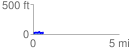
 0.583371 mi
 60.70 ft
 67.59 ft
 -6.89 ft
 2.19 %
GPX Downloads: Track Route
![]()
| at: |
Levee Bike Path (St. Gabriel Area) |
show on map
animate
0.583371 mi
60.70 ft
67.59 ft
-6.89 ft
2.19 %