| at: |
Levee Bike Path (St. Gabriel Area) |
Data from David Muse
 show on map
 animate
Trail users:

Elevation Profile
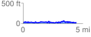
 4.455167 mi
 390.08 ft
 385.16 ft
 4.92 ft
 1.66 %
GPX Downloads: Track Route
![]()
| at: |
Levee Bike Path (St. Gabriel Area) |
show on map
animate
4.455167 mi
390.08 ft
385.16 ft
4.92 ft
1.66 %