| at: |
Middle Prong/Shining Rock Wilderness |
Data from Jason Sager
 show on map
 animate
Trail users:

Elevation Profile
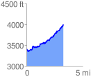
 3.288629 mi
 1027.64 ft
 466.97 ft
 560.67 ft
 5.92 %
GPX Downloads: Track Route
Trailheads:
 Big East Fork
![]()
| at: |
Middle Prong/Shining Rock Wilderness |
show on map
animate
3.288629 mi
1027.64 ft
466.97 ft
560.67 ft
5.92 %
Big East Fork