| at: |
Middle Prong/Shining Rock Wilderness |
Data from David Muse
 show on map
 animate
Trail users:

Elevation Profile
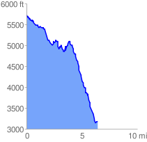
 6.557819 mi
 1316.45 ft
 3919.32 ft
 -2602.87 ft
 11.32 %
GPX Downloads: Track Route
![]()
| at: |
Middle Prong/Shining Rock Wilderness |
show on map
animate
6.557819 mi
1316.45 ft
3919.32 ft
-2602.87 ft
11.32 %