| at: |
Coopers Furnace Day Use Area |
Data from David Muse
 show on map
 animate
Trail users:

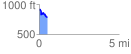
Elevation Profile
 0.503248 mi
 51.61 ft
 184.48 ft
 -132.87 ft
 6.94 %
GPX Downloads: Track Route
Trailheads:
 Coopers Furnace Day Use Area LotCoopers Furnace Nature Trail Lot