| at: |
Middle Prong/Shining Rock Wilderness |
Data from David Muse
 show on map
 animate
Trail users:

Elevation Profile
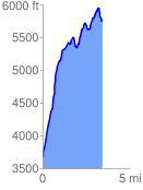
 3.435630 mi
 2582.96 ft
 498.50 ft
 2084.46 ft
 14.24 %
GPX Downloads: Track Route
![]()
| at: |
Middle Prong/Shining Rock Wilderness |
show on map
animate
3.435630 mi
2582.96 ft
498.50 ft
2084.46 ft
14.24 %