| at: |
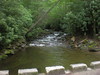
Middle Prong/Shining Rock Wilderness |
Data from David Muse
 show on map
 animate
Trail users:


Elevation Profile
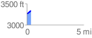
 0.372025 mi
 74.31 ft
 8.33 ft
 65.97 ft
 3.78 %
GPX Downloads: Track Route
![]()
| at: |
Middle Prong/Shining Rock Wilderness |
show on map
animate
0.372025 mi
74.31 ft
8.33 ft
65.97 ft
3.78 %