| at: |
Rich Mountain Trans North Georgia |
Data from David Muse
 show on map
 animate
Trail users:


Elevation Profile
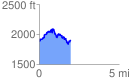
 1.961282 mi
 570.47 ft
 527.76 ft
 42.72 ft
 5.51 %
GPX Downloads: Track Route
Trailheads:
 Long Branch
![]()
| at: |
Rich Mountain Trans North Georgia |
show on map
animate
1.961282 mi
570.47 ft
527.76 ft
42.72 ft
5.51 %
Long Branch