|
| at: |
Davidson River Area |
Data from David Muse
 show on map
 animate
Trail users:


Elevation Profile
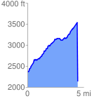
 4.508847 mi
 2862.86 ft
 1663.64 ft
 1199.22 ft
 12.03 %
GPX Downloads: Track Route
Trailheads:
 Pisgah Forest Riding Stables