| at: |
Davidson River Area |
Data from David Muse
 show on map
 animate
Trail users:


Elevation Profile
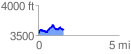
 1.587413 mi
 290.72 ft
 237.89 ft
 52.83 ft
 3.47 %
GPX Downloads: Track Route
![]()
| at: |
Davidson River Area |
show on map
animate
1.587413 mi
290.72 ft
237.89 ft
52.83 ft
3.47 %