| at: |
Davidson River Area |
Data from David Muse
 show on map
 animate
Trail users:


Elevation Profile
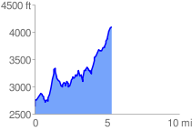
 5.342307 mi
 2508.11 ft
 1049.43 ft
 1458.68 ft
 8.89 %
GPX Downloads: Track Route
![]()
| at: |
Davidson River Area |
show on map
animate
5.342307 mi
2508.11 ft
1049.43 ft
1458.68 ft
8.89 %