| at: |
James H. Floyd State Park |
Data from David Muse
 show on map
 animate
Trail users:

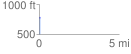
Elevation Profile
 0.066392 mi
 2.63 ft
 11.49 ft
 -8.86 ft
 3.28 %
GPX Downloads: Track Route
![]()
| at: |
James H. Floyd State Park |
show on map
animate
0.066392 mi
2.63 ft
11.49 ft
-8.86 ft
3.28 %