| at: |
North Mills River Recreation Area |
Data from David Muse
 show on map
 animate
Trail users:


Elevation Profile
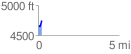
 0.200860 mi
 101.70 ft
 0.00 ft
 101.70 ft
 9.59 %
GPX Downloads: Track Route
![]()
| at: |
North Mills River Recreation Area |
show on map
animate
0.200860 mi
101.70 ft
0.00 ft
101.70 ft
9.59 %