| at: |
Davidson River Area |
Data from David Muse
 show on map
 animate
Trail users:


Elevation Profile
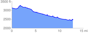
 12.983880 mi
 1441.32 ft
 2183.60 ft
 -742.28 ft
 3.19 %
GPX Downloads: Track Route
![]()
| at: |
Davidson River Area |
show on map
animate
12.983880 mi
1441.32 ft
2183.60 ft
-742.28 ft
3.19 %