| at: |
North Mills River Recreation Area |
Data from David Muse
 show on map
 animate
Trail users:

Elevation Profile
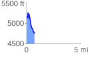
 0.733888 mi
 151.46 ft
 561.56 ft
 -410.10 ft
 14.49 %
GPX Downloads: Track Route
![]()
| at: |
North Mills River Recreation Area |
show on map
animate
0.733888 mi
151.46 ft
561.56 ft
-410.10 ft
14.49 %