| at: |
North Mills River Recreation Area |
Data from David Muse
 show on map
 animate
Trail users:


Elevation Profile
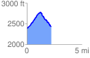
 2.275825 mi
 478.87 ft
 452.51 ft
 26.36 ft
 3.99 %
GPX Downloads: Track Route
![]()
| at: |
North Mills River Recreation Area |
show on map
animate
2.275825 mi
478.87 ft
452.51 ft
26.36 ft
3.99 %