| at: |
Fish Hatchery Area |
Data from David Muse
 show on map
 animate
Trail users:


Elevation Profile
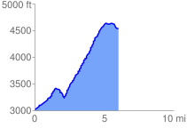
 6.087468 mi
 1885.86 ft
 398.66 ft
 1487.20 ft
 5.87 %
GPX Downloads: Track Route
![]()
| at: |
Fish Hatchery Area |
show on map
animate
6.087468 mi
1885.86 ft
398.66 ft
1487.20 ft
5.87 %