| at: |
Burnt Mountain |
Data from David Muse
 show on map
 animate
Trail users:


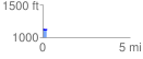
Elevation Profile
 0.248209 mi
 12.43 ft
 6.43 ft
 6.00 ft
 0.95 %
GPX Downloads: Track Route
![]()
| at: |
Burnt Mountain |
show on map
animate
0.248209 mi
12.43 ft
6.43 ft
6.00 ft
0.95 %