| at: |
Burnt Mountain |
Data from David Muse
 show on map
 animate
Trail users:


Elevation Profile
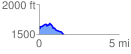
 1.533474 mi
 129.56 ft
 210.43 ft
 -80.87 ft
 2.60 %
GPX Downloads: Track Route
![]()
| at: |
Burnt Mountain |
show on map
animate
1.533474 mi
129.56 ft
210.43 ft
-80.87 ft
2.60 %