| at: |
Burnt Mountain |
Data from David Muse
 show on map
 animate
Trail users:


Elevation Profile
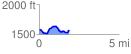
 1.857706 mi
 187.63 ft
 209.94 ft
 -22.31 ft
 2.14 %
GPX Downloads: Track Route
![]()
| at: |
Burnt Mountain |
show on map
animate
1.857706 mi
187.63 ft
209.94 ft
-22.31 ft
2.14 %