| at: |
Burnt Mountain |
Data from David Muse
 show on map
 animate
Trail users:


Elevation Profile
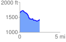
 2.488173 mi
 153.84 ft
 398.20 ft
 -244.36 ft
 3.03 %
GPX Downloads: Track Route
![]()
| at: |
Burnt Mountain |
show on map
animate
2.488173 mi
153.84 ft
398.20 ft
-244.36 ft
3.03 %