| at: |
Burnt Mountain |
Data from David Muse
 show on map
 animate
Trail users:


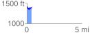
Elevation Profile
 0.421715 mi
 62.07 ft
 83.63 ft
 -21.56 ft
 3.76 %
GPX Downloads: Track Route
![]()
| at: |
Burnt Mountain |
show on map
animate
0.421715 mi
62.07 ft
83.63 ft
-21.56 ft
3.76 %