| at: |
Burnt Mountain |
Data from David Muse
 show on map
 animate
Trail users:


Elevation Profile
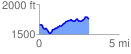
 3.111494 mi
 372.41 ft
 277.40 ft
 95.01 ft
 2.27 %
GPX Downloads: Track Route
![]()
| at: |
Burnt Mountain |
show on map
animate
3.111494 mi
372.41 ft
277.40 ft
95.01 ft
2.27 %