| at: |
Burnt Mountain |
Data from David Muse
 show on map
 animate
Trail users:


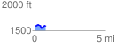
Elevation Profile
 0.761186 mi
 71.33 ft
 72.34 ft
 -1.02 ft
 1.80 %
GPX Downloads: Track Route
![]()
| at: |
Burnt Mountain |
show on map
animate
0.761186 mi
71.33 ft
72.34 ft
-1.02 ft
1.80 %