| at: |
Burnt Mountain |
Data from David Muse
 show on map
 animate
Trail users:


Elevation Profile
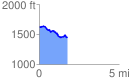
 1.760224 mi
 98.33 ft
 280.97 ft
 -182.64 ft
 3.02 %
GPX Downloads: Track Route
![]()
| at: |
Burnt Mountain |
show on map
animate
1.760224 mi
98.33 ft
280.97 ft
-182.64 ft
3.02 %